Introduction
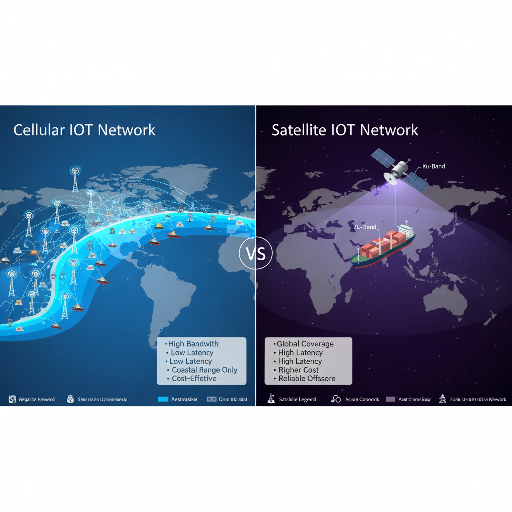
IoT and satellite communications are transforming how maritime operations maintain connectivity across Nigeria’s coastal waters and the Gulf of Guinea. As Nigerian shipping companies, port operators, and offshore industries deploy IoT devices for vessel tracking, cargo monitoring, and fleet management, the integration of cellular and satellite connectivity becomes critical for seamless operations. Traditional terrestrial networks only extend approximately five miles offshore, creating massive connectivity gaps that interrupt critical maritime communications and data transmission.
This comprehensive guide explores how universal SIM cards combined with satellite communications solve maritime connectivity challenges, the specific technologies enabling this revolution, and why multinetwork roaming SIMs represent the essential foundation for reliable vessel tracking and cargo monitoring across African waters. Whether you’re managing fishing fleets off Lagos, monitoring shipping containers through Port Harcourt, or coordinating offshore oil operations, understanding IoT devices and satellite communications ensures your maritime investments deliver measurable operational value.
1. Understanding Maritime IoT Devices and Connectivity Requirements
Maritime IoT applications demand robust devices capable of withstanding harsh marine environments while maintaining reliable connectivity as vessels transition between coastal cellular networks and open ocean satellite coverage. Identifying appropriate IoT devices for maritime operations requires understanding unique industry requirements.
Essential Maritime IoT Device Characteristics
Environmental Hardening for Marine Conditions Maritime IoT devices must survive constant saltwater exposure, high humidity, extreme temperature variations, and intense UV radiation. Look for devices with IP67 or IP68 ratings providing complete dust protection and submersion resistance. Corrosion-resistant enclosures using marine-grade stainless steel or specialized polymers ensure long-term reliability in coastal and offshore environments.
Integrated Cellular and Satellite Connectivity Modern maritime IoT devices integrate both cellular modems for coastal operations and satellite modems for open ocean communications. This hybrid approach enables automatic switching between terrestrial and satellite networks based on availability and signal quality, ensuring continuous data flow regardless of vessel location across Nigerian waters or international shipping routes.
GPS and Navigation Integration Accurate vessel tracking requires high-sensitivity GPS receivers maintaining positioning accuracy even during severe weather conditions. Advanced maritime IoT devices integrate GPS with additional positioning systems like GLONASS, Galileo, or BeiDou, providing redundancy ensuring location data remains available if individual satellite constellations experience issues.
Power Management for Extended Operations Vessels may spend weeks at sea without shore power access. Maritime IoT devices require efficient power management enabling operation on vessel electrical systems (12V/24V DC) while providing battery backup during power interruptions. Solar-powered options suit smaller vessels or buoys requiring autonomous operation for months.
Critical Software Capabilities
Automatic Network Switching Quality maritime IoT devices automatically detect available networks—cellular or satellite—and switch seamlessly without data loss or manual intervention. This intelligence proves essential as vessels move between Lagos coastal waters (cellular coverage) and Gulf of Guinea shipping lanes (satellite-only coverage).
Data Buffering and Store-Forward During connectivity transitions or temporary signal loss, devices must buffer sensor data locally and automatically transmit once connection restores. This ensures complete voyage records for regulatory compliance and operational analysis without data gaps during network handoffs.
Remote Configuration and OTA Updates Managing devices deployed on vessels across Nigerian ports and international waters requires remote firmware updates and configuration changes. Over-the-air (OTA) update capabilities enable security patches and feature enhancements without requiring vessels to return to port for physical device access.
Collision Avoidance and Safety Integration Advanced maritime IoT systems integrate with Automatic Identification Systems (AIS), radar, and collision avoidance systems, enhancing maritime safety through real-time vessel tracking and traffic management. The Nigerian Maritime Administration and Safety Agency (NIMASA) encourages such technologies improving safety across Nigerian territorial waters.
2. Satellite Communication Technologies Revolutionizing Maritime IoT
Satellite networks overcome the fundamental limitation of terrestrial cellular networks—geographic coverage. Understanding different satellite technologies helps Nigerian maritime businesses select appropriate connectivity solutions matching operational requirements and budget constraints.
Three Primary Satellite Orbit Types
Geostationary Earth Orbit (GEO) Satellites Operating at approximately 35,786 kilometers altitude, GEO satellites maintain fixed positions relative to Earth’s surface, providing consistent coverage over specific ocean regions. These satellites offer the broadest coverage footprints ideal for vessels operating within defined areas like the Gulf of Guinea. However, GEO systems experience higher latency (500-700 milliseconds) affecting real-time applications.
Nigerian maritime operations benefit from GEO satellite coverage across West African waters, supporting applications like cargo monitoring, engine telemetry, and periodic position reporting where millisecond response times aren’t critical. Cost-effective data plans make GEO suitable for high-volume maritime IoT deployments.
Medium Earth Orbit (MEO) Satellites MEO satellites operate between 2,000 and 35,786 kilometers altitude, providing balanced coverage and latency characteristics. These systems achieve 100-150 millisecond latency—five times lower than GEO—while maintaining reasonable coverage footprints reducing the total satellite constellation size required for global coverage.
Maritime applications requiring moderate real-time responsiveness, such as fleet management communications and operational coordination, benefit from MEO systems. Nigerian fishing fleets and offshore support vessels utilize MEO connectivity for crew communications and operational updates.
Low Earth Orbit (LEO) Satellites LEO satellites orbit between 160 and 2,000 kilometers altitude, delivering the lowest latency (20-40 milliseconds) and highest data transfer rates suitable for bandwidth-intensive maritime applications. However, individual LEO satellite footprints cover smaller areas, requiring large constellations (hundreds or thousands of satellites) providing continuous global coverage.
LEO systems support advanced maritime IoT applications including live video surveillance, remote vessel diagnostics, and autonomous navigation systems. As LEO constellations expand, Nigerian maritime industries gain access to high-performance connectivity previously unavailable or prohibitively expensive for commercial shipping operations.
3GPP Release 17: Standardizing IoT Over Satellite
The 3GPP Release 17 (Rel. 17) standard, completed in 2022, introduces support for Non-Terrestrial Networks (NTN) enabling NB-IoT and LTE-M protocols—originally designed for terrestrial cellular networks—to operate over satellite links. This standardization revolutionizes maritime IoT by enabling universal SIM cards to seamlessly switch between cellular and satellite networks using identical protocols.
Single SIM Solution for Hybrid Connectivity Rel. 17 compatibility eliminates the need for separate cellular and satellite SIMs, simplifying device design and reducing operational complexity. Universal SIM cards supporting both terrestrial and NTN connectivity automatically select optimal networks as vessels move between coastal and open ocean environments.
Cost Reduction Through Standardization By utilizing existing cellular protocols over satellite links, Rel. 17 reduces satellite IoT costs through economies of scale. Device manufacturers leverage existing cellular modem designs with software modifications rather than developing separate satellite-specific hardware, lowering device costs for Nigerian maritime operators.
Future-Proofing Maritime Investments Vessels equipped with Rel. 17-compatible IoT devices benefit from evolving satellite constellation deployments without hardware replacements. As satellite operators launch NTN-compatible networks, existing devices automatically gain access to improved coverage and performance through firmware updates.
3. Key Maritime Applications for IoT and Satellite Communications
Nigerian maritime industries create diverse IoT applications where satellite communications enable operations impossible using terrestrial networks alone. Understanding specific use cases helps businesses identify opportunities for technology adoption.
Vessel and Fleet Tracking
Real-Time Position Monitoring Shipping companies managing vessels across Gulf of Guinea shipping lanes require continuous position tracking for operational efficiency, security, and regulatory compliance. IoT devices with satellite communications provide uninterrupted GPS tracking from Lagos ports to international destinations, enabling route optimization and accurate estimated arrival times.
Universal SIM cards automatically maintain connectivity as vessels transition between Nigerian coastal cellular networks (MTN, Airtel, Glo, 9mobile) and satellite coverage, eliminating tracking gaps that create security vulnerabilities or operational uncertainties.
Geofencing and Route Compliance Maritime operators establish virtual boundaries alerting fleet managers when vessels deviate from planned routes or enter restricted areas. This capability enhances security against piracy in Gulf of Guinea waters—a significant concern for Nigerian maritime operations—while ensuring compliance with environmental protection zones and territorial boundaries.
Fishing Fleet Management Nigerian fishing companies deploy IoT devices on vessels operating across West African waters, monitoring vessel locations, catch reporting, and regulatory compliance. Satellite communications enable continuous monitoring even when vessels operate beyond coastal cellular coverage pursuing fish populations in international waters.
Cargo and Container Monitoring
Environmental Condition Tracking Shipping containers transporting temperature-sensitive goods require continuous monitoring ensuring proper refrigeration throughout transit. IoT sensors measuring temperature, humidity, and shock events transmit data via cellular networks in ports and satellite communications during ocean transit, providing complete cold chain visibility.
Nigerian agricultural exports including cocoa, seafood, and perishable produce benefit from this technology, reducing spoilage losses and ensuring product quality meeting international market standards. GenYZ Solutions’ universal SIM cards enable seamless connectivity as containers move through Port Harcourt, Lagos, or Tin Can Island ports onto vessels bound for global markets.
Security and Tampering Detection Container tracking devices with accelerometers and door sensors detect unauthorized access, suspicious movements, or tampering attempts. Immediate alerts via satellite communications enable rapid response to security threats, protecting valuable cargo during transit through high-risk maritime regions.
Asset Utilization Optimization Shipping companies managing thousands of containers across global supply chains use IoT tracking optimizing asset utilization and reducing empty container repositioning costs. Satellite connectivity provides visibility into container locations worldwide, improving logistics planning and reducing operational expenses.
Engine Performance and Predictive Maintenance
Remote Diagnostics and Monitoring IoT sensors monitoring engine parameters—temperature, pressure, vibration, fuel consumption—transmit data via satellite communications enabling shore-based engineering teams to analyze vessel performance in real-time. Early detection of developing issues prevents catastrophic failures requiring expensive emergency repairs or vessel downtime.
Nigerian offshore support vessels servicing oil platforms in the Gulf of Guinea utilize predictive maintenance reducing operational disruptions and improving safety for crew and cargo. Remote diagnostics minimize unnecessary port visits for routine inspections, reducing costs and improving vessel availability.
Fuel Efficiency Optimization Maritime fuel costs represent 50-60% of operational expenses for commercial shipping. IoT systems analyzing engine performance, weather conditions, and route characteristics provide recommendations optimizing fuel consumption. Satellite connectivity ensures continuous data flow supporting real-time efficiency improvements throughout voyages.
Compliance with Environmental Regulations International Maritime Organization (IMO) regulations require emissions monitoring and reporting. IoT systems automatically track fuel consumption, engine emissions, and compliance with environmental standards, transmitting data via satellite communications to regulatory authorities and company management systems.

4. Universal SIM Cards: The Foundation for Maritime Connectivity
Maritime IoT success depends on connectivity reliability as vessels transition between terrestrial cellular networks in coastal waters and satellite networks in open ocean. Universal SIM cards provide the seamless multinetwork connectivity essential for uninterrupted maritime operations.
Coastal Cellular Connectivity Benefits
Cost-Effective Data Transmission in Ports Cellular networks provide high-bandwidth, low-cost connectivity when vessels operate within five miles of coastal base stations. Universal SIM cards automatically utilize available cellular networks—MTN, Airtel, Glo, or 9mobile—when vessels dock at Nigerian ports or navigate coastal shipping lanes, minimizing expensive satellite data usage.
Large data transfers including voyage reports, maintenance logs, crew communications, and system updates occur via cellular networks while vessels remain in port, significantly reducing monthly connectivity costs compared to satellite-only solutions.
Multinetwork Redundancy No single cellular operator provides comprehensive coverage across Nigeria’s entire coastline from Lagos to Calabar. Universal SIM cards automatically switch between available operators ensuring continuous connectivity as vessels move between different coastal regions where network coverage varies significantly.
Satellite Connectivity for Open Ocean Operations
Global Coverage Beyond Terrestrial Limits Once vessels move beyond coastal cellular range—approximately five miles offshore—satellite communications become the only connectivity option. Universal SIM cards with integrated satellite profiles automatically transition to satellite networks maintaining uninterrupted data transmission for critical maritime IoT applications.
Gulf of Guinea shipping lanes, offshore oil platforms, and international fishing grounds all require satellite connectivity for vessel tracking, cargo monitoring, and crew safety communications. GenYZ Solutions provides universal SIM cards supporting both cellular and satellite networks through single device installations.
Network Selection Intelligence Advanced SIM management platforms allow maritime operators to configure network selection preferences optimizing costs while maintaining required connectivity levels. Devices can prioritize cellular networks when available (lower cost) while automatically failing over to satellite networks when cellular coverage becomes unavailable.
Hybrid Connectivity Advantages
Seamless Network Transitions Quality maritime IoT devices with universal SIM cards execute network transitions within seconds, maintaining data flow without interruption or manual intervention. This seamless switching proves critical for applications like vessel tracking where continuous position reporting ensures operational visibility and security.
Reduced Operational Complexity Single universal SIM cards eliminate the need for separate cellular and satellite SIM cards, multiple carrier relationships, and complex device configurations. Maritime operators manage all connectivity through unified platforms regardless of whether vessels currently utilize cellular or satellite networks.
Scalable Solutions Across Vessel Types From small fishing boats operating coastal waters to large container ships traversing international routes, universal SIM cards provide appropriate connectivity for diverse maritime applications. Fleet operators standardize on single connectivity solutions rather than managing different technologies across different vessel types.
5. Selecting Maritime IoT Solutions: Critical Considerations for Nigerian Operators
Successfully deploying maritime IoT and satellite communications requires careful evaluation of technology options, connectivity partners, and implementation strategies matching specific operational requirements.
Device Selection Criteria
Environmental Certifications Verify devices hold marine environmental certifications including IP67/IP68 ratings, salt spray resistance testing (ASTM B117), and operational temperature ranges (-20°C to +70°C) covering extreme marine conditions. Devices lacking proper certifications experience premature failures in harsh maritime environments.
Connectivity Protocol Support Ensure devices support both cellular technologies (3G/4G/NB-IoT/LTE-M) for coastal operations and appropriate satellite protocols (LEO/MEO/GEO) for open ocean connectivity. Rel. 17 NTN compatibility future-proofs investments as standardized satellite IoT networks deploy globally.
Battery and Power Management Evaluate power consumption profiles and battery backup capabilities ensuring devices maintain operation during vessel power interruptions. Solar-powered options suit small vessels or buoys requiring autonomous operation, while wired devices integrate with vessel electrical systems on larger ships.
Sensor Integration Capabilities Maritime applications require diverse sensors—GPS, accelerometers, temperature, humidity, door contacts, fuel flow meters, engine diagnostics. Select devices offering appropriate sensor inputs or choose complete integrated solutions matching application requirements.
Connectivity Partner Evaluation
Network Coverage Verification Request detailed coverage maps showing both cellular coverage across Nigerian coastal waters and satellite coverage across operational areas including the Gulf of Guinea and international shipping routes. Verify coverage matches actual vessel routes rather than accepting generic global coverage claims.
Transparent Pricing Models Understand all costs including device acquisition, monthly cellular data plans, satellite airtime charges, platform access fees, and overage rates. Request pricing in Naira for Nigerian operations to avoid currency fluctuation surprises. Compare total cost of ownership over 3-5 years including projected data consumption.
SIM Management Platform Capabilities Evaluate platforms providing real-time device monitoring, remote configuration, automated alerts, data usage tracking, and network performance analytics. Quality platforms enable proactive management of devices deployed across distributed vessel fleets without requiring physical access.
Technical Support Accessibility Maritime operations occur 24/7 requiring connectivity support matching operational schedules. Verify support team availability, response times, and technical expertise resolving both cellular and satellite connectivity issues. Local Nigerian support teams understand regional challenges better than distant international call centers.
Regulatory Compliance Considerations
NIMASA Requirements The Nigerian Maritime Administration and Safety Agency (NIMASA) establishes regulations for vessel tracking, safety equipment, and maritime communications. Ensure selected IoT solutions comply with NIMASA requirements including vessel monitoring systems (VMS) for commercial fishing vessels and cargo tracking mandates.
International Maritime Standards Vessels operating in international waters must comply with International Maritime Organization (IMO) standards including SOLAS (Safety of Life at Sea) requirements for communications equipment. Verify IoT systems meet relevant international certifications enabling compliance across multiple jurisdictions.
Data Privacy and Security Maritime IoT systems collect sensitive operational data, cargo information, and vessel positions requiring protection against unauthorized access. Ensure solutions provide end-to-end encryption, secure authentication, and compliance with data protection regulations including Nigeria’s data privacy frameworks.
Implementation Best Practices
Pilot Testing Before Fleet-Wide Deployment Deploy IoT devices on 2-3 representative vessels for 3-6 months testing performance across actual operational routes, environmental conditions, and connectivity transitions. Monitor device reliability, data accuracy, connectivity uptime, and total costs before committing to fleet-wide installations.
Crew Training and Procedures Successful maritime IoT adoption requires crew understanding of systems, basic troubleshooting procedures, and protocols for reporting issues. Provide training in local languages ensuring all personnel can effectively utilize and maintain IoT equipment throughout voyages.
Integration with Existing Systems Maritime IoT delivers maximum value when integrated with existing vessel management systems, fleet operations platforms, and business analytics tools. Ensure selected solutions provide APIs or standard protocols enabling seamless data exchange with current infrastructure.
Conclusion: Partner with Genyz Solutions for Maritime IoT Excellence
IoT and satellite communications are revolutionizing maritime operations across Nigerian waters and beyond. Traditional terrestrial networks create connectivity gaps interrupting critical vessel tracking, cargo monitoring, and fleet management operations. Universal SIM cards providing seamless transitions between cellular and satellite networks ensure continuous connectivity regardless of vessel location.
Genyz Solutions delivers comprehensive maritime IoT connectivity specifically designed for Nigerian shipping companies, fishing fleets, and offshore operators. Our universal SIM cards work seamlessly across MTN, Airtel, Glo, and 9mobile coastal cellular networks while providing integrated satellite connectivity for open ocean operations across the Gulf of Guinea and international shipping routes.
Our proven experience supporting mission-critical applications for financial institutions including FCMB and Wema Bank demonstrates our capability delivering reliable connectivity where failure creates unacceptable operational and financial risks. We understand Nigerian maritime challenges and provide local technical support ensuring your fleet remains connected and operational.
Whether you’re managing commercial shipping vessels, coordinating fishing operations, supporting offshore oil platforms, or tracking cargo containers through Nigerian ports, Genyz Solutions provides the multinetwork connectivity infrastructure, technical expertise, and local market knowledge transforming maritime IoT concepts into operational realities.
Start Your Maritime IoT Journey Today
Don’t let connectivity limitations restrict your maritime operations. Contact Genyz Solutions for a free consultation evaluating your specific requirements. Our team will assess your vessel types, operational routes, application needs, and recommend optimal IoT devices and universal SIM card solutions delivering the reliability Nigerian maritime businesses demand.
.